Common menu bar links
Description of Shipwrecks
Introduction
The mapping of Halifax Harbour has revealed the presence of about 45 shipwrecks in the harbour. Near the mouth of the harbour, over 50 magnetic anomalies have been discovered, most of which also represent shipwrecks. There may be many others that are buried beneath the muddy sediments that require other techniques for discovery. Together they represent a rich archaeological heritage yet to be fully explored.
Shipwrecks exhibit unique characteristics on sidescan sonograms resulting from: their hardness, shape and distinctive features such as railings, masts, smokestacks, funnels, bows, anchors, chains, hatches, and deck openings. They are much different from natural geological features such as boulders and bedrock. Shipwreck characteristics are better portrayed on sidescan sonograms, as the systems are towed closer to the seabed and have higher resolution to see details.
Most of the shipwrecks found in the harbour were unknown before the study of the marine geology. Some are known wrecks such as the ferry Governor Cornwallis that sank on the southeast flank of Georges Island as a result of an onboard fire, whereas others remain unknown and require further study for identification. They represent many marine tragedies that occurred in the harbour. It is important to map their location, the height of their protrusion above the seabed, and to determine their identity as they can represent hazards to navigation if their upper structures rise high above the seabed. Some also contain unexploded ordnance or other dangerous cargoes and some represent both military and civilian grave sites.
The following is a description of ten of the larger and more famous shipwrecks in Halifax Harbour. Many other shipwrecks occur throughout the harbour. These include several barges, old scuttled ships in Bedford Basin, a recently discover copper-clad schooner in The Narrows that may be related to the Halifax Explosion, old ferries, and several others in the Northwest Arm that have not as yet been identified.
Governor Cornwallis
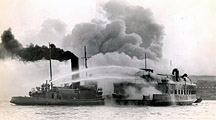
A photograph of the Governor Cornwallis on fire in Halifax Harbour with a fire boat attempting to put it out.
The Canadian Hydrographic Service discovered an old wreck off the southeast corner of Georges Island during their charting in the 1980s. It was located with echosounders and mapped on the charts of Halifax Harbour. During the survey of the harbour with sidescan-sonar systems, clear images were obtained. It partially rests on its side with the shallow part overlying hard gravel bottom and the deepest part buried in mud. The superstructure appears to have been damaged and short linear features occur on the deck surface. Divers have confirmed that these features are radiators used for heating the passengers for cold morning Halifax Harbour crossings. The multibeam bathymetry map shows the location of the Governor Cornwallis on the side of Georges Island.
The Governor Cornwallis was a ferry boat designed to carry cars, trucks, and passengers between Halifax and Dartmouth. On December 22, 1944, as it left Halifax, bound for Dartmouth, the ferry caught fire. It calmly proceeded to the Dartmouth shore which it discharged all the vehicles and passengers and was towed toward the middle of the harbour. There, the blaze erupted into a major fire with the upper structure completely engulfed. It burned to the water line and sank to the bottom of the harbour where it remains today.
Erg
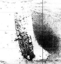
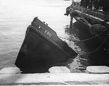
The Erg was a former dockyard service boat that sank due to a collision in the central area of Bedford Basin in 1943. It was on its way to service a ship in a convoy that was anchored. It resulted in the loss of 19 lives. After the collision the Erg was refloated and some of the bodies were recovered. The Navy then finally sunk the ship in off Roach Cove in the northern part of the basin. After the discovery with sidescan sonar, divers visited the wreck and placed a plaque in honour of those who lost their lives.
Good Hope
The Good Hope, a fishing trawler, was found near Middle Ground in the outer part of Halifax Harbour. It sank as the result of a collision with another vessel. Its upper structures were later blasted down by the military as it was in the main entrance channel to the harbour and posed a hazard to navigation.
Havana
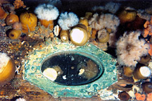
A photograph of the wooden hull of the Havana showing a porthole with the glass remaining, from diver Terry Dwyer.
The Havana lies to the southwest of Ives Knoll and was a 55 m salvage schooner owned by Captain J.A. Farquar. It was in the process of salvaging another ship the Alexander R. when it was struck amidships by the steamer Strathcona on April 26th, 1906. It is rumoured to contain a presentation sextant given by the British Admiralty for salvaging the guns of H.M.S. Niobe in 1874. It has been examined by divers.
Gertrude de Costa
To the south of the Havana, off the South End Container Terminal, lies another schooner, which has been determined to be the Gertrude de Costa. It was involved in a collision with an oil tanker the Island Connector in the harbour in 1950. Seven seamen went down with the vessel. It was a wooded schooner over 30 m in length with two masts, both of which lie on the seabed adjacent to the wreck. When explored by divers, several relatively modern batteries, a fire extinguisher, and most importantly an engine with a panel of gauges strongly suggested that the vessel was relatively modern, and indeed, the Gertrude de Costa. Unexploded ordnance lies on the deck of the Gertrude de Costa. The origin of the ordnance is not known, but in any case, it represents a hazard. This illustrates the importance of identification of shipwrecks to assess their hazard potential as well as their historical value.
Barge in Bedford Basin
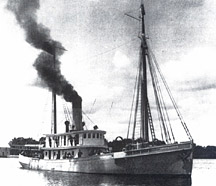
A photograph of the ship Deliverance, a diving tender that sank at the entrance to Herring Cove, Halifax Harbour after being rammed by the Norwegian steamer Regin.
A barge was found on the seabed in Bedford Basin next to the dock of the military magazine. This was the barge on which a small fire started in 1945 that spread to the adjacent dock setting off a series of major explosions that rocked the region of Halifax for over 24 hours. The event is termed the "Magazine explosion of 1945" and although less forceful than the Halifax Explosion of 1917 in The Narrows, it created fear and panic in the community and resulted in much damage.
Deliverance
The Deliverance is a shipwreck off the entrance to Herring Cove in the outer harbour. It was a steam-engined diving tender that sank after a collision with the steamer Regin in 1917. The upper structures have collapsed and a large boiler dominates the ship structure. It lies in 30 m of water and is a popular recreational dive location. A large scour existed around the hull of the shipwreck from strong currents. Recent infill of the seabed in the scour is attributed to sediment transport during Hurricane Juan in 2004.
British Freedom
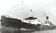
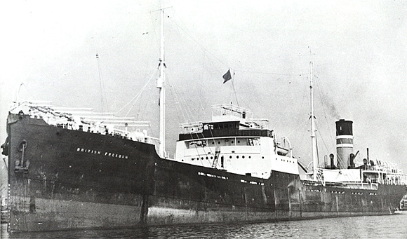
A photograph of the British Freedom, a tanker that sank off Chebucto Head in 1945, in outer Halifax Harbour after being torpedoed by a German u-boat.
The British Freedom and the Athelviking, both tankers, were torpedoed by a German U-boat on the same day in 1944 off the mouth of Halifax Harbour. The British Freedom sank off Chebucto Head with the loss of only one person. It lies on a gravel bottom near the major shipping lanes and was found by the DND during seabed mapping exercises. The ship has several deck guns and is a popular diving site. Hurricane Juan shifted the shipwreck and broke some of it apart.
Kaaparen
The Kaaparen, a Swedish cargo vessel loaded with military materials and nickel and aluminum ingots, sank after a collision with the Tungsha at the entrance of the harbour. The valuable cargo was later salvaged after blasting open the hull and removing metal ingots with a large grab. Much of the shipwreck still remains on the bedrock of the seabed including tank treads, the propellers, and the ships wheel.
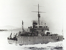
A photograph of the HMCS Clayoquot at sea. Compare the profile of the ship with the sidescan image above.
Clayoquot
The HMCS Clayoquot was a Bangor Class minesweeper and was torpedoed on Christmas Eve, 1944, with loss of life. The torpedo was launched by a German U-boat patrolling the entrance to Halifax Harbour. The ship lies in 91 m of water on the edge of a large channel at the entrance to the harbour. Recent dives to the shipwreck show that it is in pristine condition with a large fore deck gun and the stern is badly destroyed from the strike by an acoustic homing torpedo.

