Common menu bar links
Busting Harbour Myths

The tale of the cursed bridges of the Narrows
Crater from the Halifax Explosion?
-
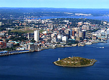
An aerial photograph of part of inner Halifax Harbour showing the relative location of Citadel Hill and Georges Island. One of the Harbour myths suggests that a tunnel beneath the Harbour connects the two early fortifications.Perhaps the most persistent and well-known myth about Halifax Harbour is the idea that a tunnel runs beneath the Harbour and connects The Halifax Citadel National Historic Site of Canada locally called Citadel Hill with Georges Island. These were two of the major early British fortifications within the harbour.
Both of these hills called drumlins (mounds of gravel, sand, silt and clay deposited by glaciers) are the sites of former military forts that were easily dug into the soft material. The story is continually fueled every time work is done on the downtown streets that involve replacing or repairing water and sewer pipes. On numerous occasions these street excavations have broken into chambers and tunnels that are lined with brick and in some cases are large enough to walk through. Some of them head to the harbour between Georges Island and "Citadel Hill".
During the geological study of the harbour, seismic-reflection systems were used to look beneath the bottom of the harbour to understand the sediments and bedrock. These systems use sound to penetrate the bottom and images are produced that show layering of the sediments and rocks. Surveys were conducted between Georges Island and the Halifax shoreline and the images showed no evidence of tunnels or flooded tunnels. Surveys have been conducted in other cities with tunnels and they clearly show up on the imagery. Thus, there does not appear to be any under harbour connection between Georges Island and "Citadel Hill".
The tale of the cursed bridges of The Narrows
An ancient legend claims that a curse was put on The Narrows that will cause three bridges to fall in these waters. It was placed by a Native in revenge for the death of his girlfriend. Archives show that in fact two bridges use to span the narrows, but both disappeared due to strange circumstances. Will the A. Murray MacKay Bridge, the third built, be able to withstand the curse? Using side-scan sonar and multibeam bathymetry, scientists have discovered the mystery as to why these two bridges, one build in 1884 and the other in 1893 collapsed, and why it is likely the A. Murray MacKay Bridge will withstand this curse.
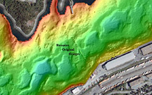
An unusual pattern of large rectangular objects that span across The Narrows were discovered while mapping the seabed in 1989. A visit to the Nova Scotia Public Archives showed that remains of not one, but two original harbour-crossing bridges had been found.
The two bridges were built at the same location, approximately 500 m south of the present A. Murray Mackay Bridge. Further studies with cameras, samplers, and multibeam-bathymetric mapping systems revealed details of the bridge remains, but more importantly told the story of why both bridges collapsed.
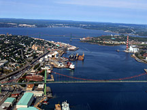
An aerial photograph of The Narrows of Halifax Harbour defined as the region between the two bridges. The original bridge crossed the Harbour approximately 500 m south of the A. Murray Mackay Bridge in the distance.The first bridge was completed in May 1884 and had a steel swing section made by the Starr Manufacturing Company of Dartmouth that was located near the Dartmouth shoreline and designed to open and allow ships to move into Bedford Basin. The bridge was over a quarter of a mile in length and up to 12 m in width. It was built mainly as a railway bridge but a foot path existed alongside the track and an average of 125 train cars used the bridge daily.
The bridge had been built on wooden piers with each base containing 18.12 metric tons of rock ballast (rocks carried on board ships to make them maore stable). These are the rectangular features seen on the sidescan imagery. On September 7, 1891 a hurricane hit Halifax Harbour with winds reported to be as high as 112 kilometres per hour. Much damage was done to the docks of the Harbour and a large portion of the bridge collapsed during the night. Everything from 61 metres out on the Halifax side to the swing section near Dartmouth washed away.
After lengthy deliberations, a second bridge was built in the same location, but this time using piles pounded into The Narrows seabed for support. This bridge appeared unstable after completion and granite blocks were place on the seabed beside the bridge and connected with cables to make it more stable. Despite these efforts, the second bridge floated away on July 6, 1893 after a strong tide essentially lifted it from its foundation on a quiet summer night.
Camera and multibeam bathymetric surveys show that much of the original cribwork of the first bridge is still intact rising above the bottom by several metres. The multibeam map shows the cribwork and the circular pier base for the swing section on the seabed. Much of the cribwork and rail track are covered with sea anemones fed by the nutrient-rich fast-moving waters in The Narrows. The seabed consists of gravel with boulders and is swept clean of muddy sediments by strong tidal currents. The hard geological conditions of the seabed and the strong currents provide an answer as to why the bridges collapsed. The hurricane that brought down the original bridge separated it from its cribwork base. The second disaster was likely the result of the failure of the pilings to properly penetrate into the hard seabed. The present A. Murray McKay Bridge is built on solid bedrock.Crater from the Halifax Explosion?
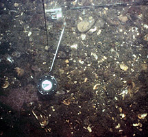
A bottom photograph of the Narrows seabed showing gravel and shells. The compass is the trigger weight for the camera system and a fishing rod and reel can be seen.Another one of the myths of Halifax Harbour is that the Halifax Explosion of 1917 developed a large crater in the bottom of the Harbour. In his 1941 book "Barometer Rising", author Hugh MacLennan wrote: "Underneath the keel of the Mont Blanc the water opened and the Harbour bottom was deepened twenty feet along the channel of The Narrows; the rigid ironstone and granite base of Halifax peninsula rocked and reverberated, pavements split and houses swayed as the earth trembled". But is this true?
The 1917 explosion occurred on the Halifax side of The Narrows in Halifax Harbour, when, after collision with the ship Imo, the cargo aboard the ammunition ship Mont Blanc erupted into one of the world's largest non natural explosions prior to the detonation of atomic bombs. The marine geological and geophysical surveys show that the seafloor of The Narrows is unlike most other areas of the inner harbour. It consists of cobble-and boulder-sized gravel with outcropping bedrock. The currents are strong enough to prevent significant deposition of fine-grained sediments. Beneath the gravel, the material consists of exceptionally hard till deposited by glaciers, which likely occupied the harbour many times during the Quaternary.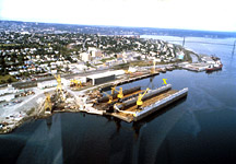
An aerial photograph of part of The Narrows where the Halifax Explosion took place. An X marks the spot where the Mont Blanc exploded.An interpretation of all the survey information indicates that there is no crater formed by the explosion. The seafloor does not also have large pieces of debris that would be expected to remain from the destruction of a large vessel such as the Mont Blanc. It is suspected that post explosion clearance and dredging programs may have removed the debris. Many small sidescan-sonar targets occur on the seabed of The Narrows and some may represent debris from the explosion of 1917, but they require visual identification.
The energy generated by the blast from the explosion on the Mont Blanc was likely directed outward and upward because of the hardness of the seabed. The minimal impact to the seabed at the site of the explosion in Halifax Harbour is in contrast to the impact of nuclear test explosions at Enewetak Atoll, Marshall Islands, which formed craters up to 60 metres deep and 1200 metres in diameter.
Recently, during surveys conducted by DND in The Narrows near the site of the Halifax Explosion, a new shipwreck, a copper-clad schooner was found. Research continues on this wreck and it is thought to have sunk during the Halifax Explosion, thus adding a new chapter to the story 90 years later.

