
Natural Resources Canada
www.nrcan.gc.ca
Common menu bar links
Pictures and Maps
-
- Map showing the geographic divisions of Halifax Harbour.
- Diagram showing how oceanographic and marine geological information is collected at sea using a variety of ship-mounted and-towed devices.
- A typical seismic-reflection profile and interpretation from inner Halifax Harbour showing buried lake sediments (lacustrine) beneath recent mud (LaHave Clay).
- A sidescan record of a sunken barge in Bedford Basin on a seabed criss-crossed with anchor marks.
- A bottom photograph of mud in the inner harbour and typical discarded material on the seabed. The small black features on the seabed are worm tubes.
- A map of the distribution of sediments and bedrock at the seabed of Halifax Harbour.
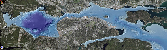
- A multibeam-bathymetric map of water depths in Bedford Basin. It is colour coded to depth with the deepest area in blue and 71 m deep. It is also shaded with a computer-generated artificially sun that produces shadows and allows the image to be interpreted as an aerial photograph of land.
- A map of the world showing a reconstruction of the super continent Gondwana and Pangea just before the breakup and the formation of the Atlantic Ocean.
- A bedrock map of Nova Scotia showing the location of Halifax Harbour.
- A detailed map of the bedrock geology of Halifax Harbour and surrounding areas. The slashes that cross the harbour represent folds (synclines and anticlines) in the bedrock. The harbour widens at the anticlines.
- A multibeam-bathymetric image of Lighthouse Bank in the outer harbour near McNabs Island showing bedrock ridges at the seabed and a small offset in the ridges (fault).
- Bottom photographs of the three bedrock types that occur beneath the harbour.
- A multibeam-bathymetric image showing that the footing for the Angus L. Macdonald Bridge lies on one of a set of four bedrock ridges at the seabed.
- A map of the sediments on the inner Scotian Shelf off Halifax Harbour showing the channel of the ancient Sackville River.
- A map of water depths in Halifax Harbour with the location of a former river channel, the ancient Sackville River that existed when sea level was lower.
- A map of the morphology (topography) of the regional area around Halifax Harbour showing the location of a drainage system through the Dartmouth lakes and where it emptied into the harbour.
- A multibeam-bathymetric image of the southern part of The Narrows showing the location of a small section of the ancient Sackville River that flowed through the harbour when sea level was lower.
- A photograph of Chebucto Head showing the steep and rugged granite cliffs that form the western shore of the outer harbour.
- A map showing the centre (E for Escuminac) of the last glacier that flowed across Nova Scotia centred over the Gulf of St. Lawrence.
- A map of the area surrounding Halifax Harbour showing the different materials overlying bedrock. Note the drumlins (glacial hills of till) in red.
- A 3-d multibeam-bathymetric image looking north toward an end moraine (ridge of till) at the head of the Northwest Arm deposited by a glacier that terminated there.
- A multibeam-bathymetric map off the entrance to Halifax Harbour. The white line is the location of the low sea-level stand (beach) at approximately 12 000 years ago.
- A photograph of the southern area of McNabs Island showing the red Lawrencetown Till being eroded at the shore face and the boulder beach that develops.
- A map showing the location of 10 lakes that existed in Halifax Harbour after the glaciers left and before the sea level returned and flooded the harbour.
- A sidescan-sonar image of two boulder berms (ridges of boulders) in Bedford Basin that mark an old lakeshore. They now lie in 23 m water depth and were formed approximately 6000 years ago.
- A multibeam-bathymetric image of the northern part of Bedford Basin showing smooth seabed above the boulder berms at 23 m water depth, and rough seabed below.
- A 3-d multibeam-bathymetric image of the western side of Bedford Basin showing the location of two large former islands defined by the boulder berms that ring them. They presently occur in water depths of less than 23 m.
- A multibeam-bathymetric image of the junction between Bedford Basin and Bedford Bay. Here the seabed consists of ridges of exposed bedrock. An ancient waterfall would have cut across the largest bedrock ridge when the basin was a series of lakes.
- A map showing the distribution and amount of mercury in seabed sediments of Halifax Harbour (prepared by Dale Buckley).
- A map of the outer part of Halifax Harbour showing a variety of bed forms in sand and gravel at the seabed formed by strong currents and large waves.
- A sidescan-sonar image of the outer part of Halifax Harbour showing how the seabed ranges from bedrock in the shallow costal zone through an area of ripples in gravel to sand in deeper water.
- Sidescan-sonar images of the seabed in the outer harbour showing a region of unusual gravel circles adjacent to steep Bear Cove Shoal.
- A bottom photograph inside a gravel circle showing that it is composed of gravel including small boulders.
- A multibeam-bathymetric image of seabed features called sedimentary furrows in the western part of the outer harbour. They occur as linear depressions in mud formed by strong currents that move from south to north.
- A multibeam-bathymetric image of an area of Halifax Harbour to the south of Pleasant Shoal showing a large moat or depression. It occurs at the junction between mud and gravel where the seabed shallows. It is the result of nondeposition of sediment by currents.
- A multibeam-bathymetric image of part of Halifax Harbour around Georges Island. A large moat has formed in this region because the currents increase in strength as they flow around the island and prevent sediments from being deposited. Note the Governor Cornwallis shipwreck.
- A seismic-reflection profile from the Georges Island moat area of Halifax Harbour. It shows that the moat has been there for a very long time.
- An interpretation of the multibeam bathymetry from around Georges Island that shows the location of the moat (5) and a sediment drift (3) to the north of the island. Area 9 represents the flank of Georges Island.
- An aerial photograph of the inner part of the Northwest Arm. The bottle collector hole occurs in the narrowest area opposite Sir Sandford Fleming Park (Dingle).
- A 3-d multibeam-bathymetric image looking up the Northwest Arm at the bottle collector hole.
- A bottom photograph of three bottles in the bottle collector hole of the Northwest Arm.
- Four seismic-reflection profiles from Halifax Harbour showing what methane gas in sediments looks like. The sound from the seismic systems does not penetrate the gas-charged sediments.
- An interpretation of multibeam bathymetry from the central deep part of Bedford Basin. The regions in yellow are large depressions that were formed by the release of methane gas.
- A multibeam-bathymetric image from the entrance to the Northwest Arm showing a field of circular pockmarks (gas-escape craters) at the seabed.
- A 3-d multibeam-bathymetric image of the pockmark field at the entrance to the Northwest Arm.
- A multibeam-bathymetric image of the central part of Bedford Basin showing many anchor marks at the seabed.
- Sidescan-sonar images of Halifax Harbour seabed showing a variety of marks formed by ship anchoring.
- Maps showing the distribution and density of anchor marks on the seabed of Bedford Basin and inner Halifax Harbour.
- A sidescan-sonar image of circular dredge spoils at the seabed of Bedford Basin.
- A multibeam-bathymetric image of an area of The Narrows of Halifax Harbour showing a cluster of circular dredge spoils on the seabed. These dredge spoils may represent material from the cleanup of the Halifax Explosion.
- A multibeam-bathymetric image from Halifax Harbour showing a dredged drumlin “Little Georges Bank” on the seabed. The top was removed to increase the water depth for safe navigation. Note the dredge spoils nearby.
- A multibeam-bathymetric image from an area of The Narrows that was blasted and dredged to increase water depths. The feature was a bedrock high.
- A multibeam-bathymetric image from the seabed of Halifax Harbour to the north of McNabs Island showing aggregate mining pits at the seabed left from the removal of sand and gravel.
- A multibeam-bathymetric image of an area of Halifax Harbour between Reed Rock and Ives Knoll. The breakwater to Reed Rock was built in 1913 and it narrowed this part of the Harbour by approximately 25%.
- A multibeam-bathymetric image of the area around Georges Island showing the shipwrecked ferry the Governor Cornwallis lying to the side of the island.
- A sidescan-sonar image of the Governor Cornwallis to the side of Georges Island.
- A photograph of the Governor Cornwallis on fire in Halifax Harbour with a fire boat attempting to put it out.
a) A photograph of a convoy in Bedford Basin during World War 2. A reconstruction of the collision with the Erg is shown in red.
b) A photograph of the bow of the Erg after it was partially refloated from Bedford Basin by dragging.
c) A multibeam-bathymetric image from Bedford Basin showing the final resting location of the Erg where it was purposely sunk in a ceremony by the military. - A sidescan-sonar record of the Good Hope shipwreck in Halifax Harbour. Some the upper parts of the ship have been blasted to prevent them from being a hazard to navigation.
- A multibeam-bathymetric image of the shipwreck Good Hope in the outer part of Halifax Harbour.
- A multibeam-bathymetric image of the seabed of Halifax Harbour between north McNabs Island and Point Pleasant Park showing the location of two shipwrecks, the Havana and the Gertrude de Costa. Note the current scour around them.
- A photograph of the wooden hull of the Havana showing a porthole with the glass remaining, (from diver Terry Dwyer).
- A sidescan sonar record of the Gertrude de Costa shipwreck in Halifax Harbour. Note the mast lying on the seabed.
- A photograph of a panel of engine gauges from the shipwreck Gertrude de Costa in Halifax Harbour, (from diver Terry Dwyer).
- A sidescan-sonar record of the seabed of Bedford Basin showing a sunken barge. This is thought to be the barge that started the fire that resulted in the Magazine Explosion of 1945 in Bedford Basin.
- A photograph of the ship Deliverance, a diving tender that sank at the entrance to Herring Cove, Halifax Harbour after being rammed by the Norwegian steamer Regin.
- A sidescan-sonar record of the Deliverance on the seabed. A large current scour had formed around the shipwreck, but was filled in with sediment during Hurricane Juan in 2003.
- A photograph of the British Freedom, a tanker that sank off Chebucto Head in 1945, in outer Halifax Harbour after being torpedoed by a German U-boat.
- A sidescan-sonar image of the British Freedom on the seabed at the mouth of Halifax Harbour. Note the current scours around both ends of the shipwreck.
- A sidescan-sonar record of a shipwreck the Kaaparen that was sunk in 1942 after collision with Tungsha while forming a convoy. It was later salvaged for a cargo of metal ingots and other valuable goods.
- A photograph of the bow of the Kaaparen off the mouth of Halifax Harbour. The hull of the ship has “rusticles” (iron/bacteria icicle-like growths) similar to those found on the hull of the Titanic in the North Atlantic.
- A sidescan-sonar record of the HMCS Clayoquot on the seabed at the mouth of Halifax Harbour. This is the discovery image and the sharp bow, deck gun, and bridge can clearly be seen.
- A photograph of the HMCS Clayoquot at sea. Compare the profile of the ship with the sidescan image.
- A sidescan-sonar image of a cable on the seabed of Halifax Harbour. Where the seabed is sand, the cable is buried and where it is gravel, it lies on the seabed.
- A multibeam-bathymetric image of the seabed of Halifax Harbour in an area where antisubmarine nets were positioned during World War II. Slight depressions occur on the seabed beneath where the nets crossed the harbour. Larger depressions are the result of current scour around concrete weights used to hold the nets in place.
- A photograph of the antisubmarine nets between Sandwich Point and McNabs Island during World War II. Ships were used as gate boats to open and close the nets to let ships pass. Compare this image with the multibeam image from the seabed.
- A multibeam-bathymetry image of Roach Cove, Bedford Basin that shows pits and depressions at the seabed formed by the detonation of underwater explosives.
- A 3-d multibeam-bathymetric image of the inner part of Halifax Harbour to the north of Georges Island looking south. Georges Island protrudes from the seabed on the right of the image. The two mounds of mud on the lower left are ridges of mud squeezed up by the sinking of the Trongate.
- An artist's (Derek Sarty) representation of the Trongate sitting on the bottom of Halifax Harbour and squeezing up the soft mud on both sides of the hull.
- A photograph of unexploded ordnance (.303 bullets and cordite (white straw-like material) at the location of the Trongate site in Halifax Harbour.
- A sidescan-sonar record of discarded 1969 Volvo automobiles on the floor of Bedford Basin along with anchor marks.
- An aerial photograph of part of inner Halifax Harbour showing the relative location of The Halifax Citadel National Historic Site of Canada locally called Citadel Hill and Georges Island. One of the harbour myths suggests that a tunnel beneath the Harbour connects the two early fortifications.
- A seismic-reflection profile between Georges Island and Halifax. There is no evidence for a tunnel in the sediments or bedrock.
- A sidescan-sonar record of part of The Narrows showing a linear pattern of cribwork at the seabed that formed the base for the first bridge to cross Halifax Harbour constructed in 1886.
- A photograph of the first bridge to cross Halifax Harbour. Note the swing section near the Dartmouth shoreline.
- A multibeam-bathymetric image of The Narrows showing the remains of the first bridge on the seabed.
- An aerial photograph of The Narrows of Halifax Harbour, defined as the region between the two bridges. The original bridge crossed the harbour approximately 500 m south of the A. Murray Mackay Bridge in the distance.
- A high-resolution sidescan-sonar record of the original bridge remains on the seabed of The Narrows. The cribwork consists of a wood frame filled with boulders, and rail track can be seen.
- A bottom photograph of The Narrows seabed showing gravel and shells. The compass is the trigger weight for the camera system and a fishing rod and reel can be seen.
- An aerial photograph of part of The Narrows where the Halifax Explosion took place. An X marks the spot where the Mont Blanc exploded.
- A multibeam bathymetric image of part of The Narrows where the Halifax Explosion took place. An X marks the location where the Mont Blanc exploded.
- A sidescan-sonar record (from DND) of an area of The Narrows showing a recently discovered shipwreck. Divers have confirmed that it is a schooner with the hull clad in copper. It is thought to have been a victim of the Halifax Explosion of 1917.
- A sidescan-sonar record of the seabed of the Northwest Arm at the Royal Nova Scotia Yacht Squadron anchorage area showing anchor-drag marks form Hurricane Juan in 2003.
- A map of part of Halifax Harbour showing the recommended locations for sewage treatment plants and marine outfalls based on recommendations of the Halifax Harbour Solutions Advisory Committee. Options 1, 3, and 4 are presently under construction.
- A multibeam bathymetric image from inner Halifax Harbour off the location of the new sewage treatment plant in Dartmouth showing the new outfall placed on the seabed.