Common menu bar links
The Origin of Halifax Harbour

Glaciation, drumlins and moraines
Lake Bedford, former islands and old shorelines
Plate tectonics
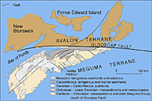
The ultimate location and formation of Halifax Harbour is related to the theory of plate tectonics whereby the continents have drifted over the Earth, and oceans have opened and closed during the last billion years. Alfred Wegener (1880–1930) is credited with first conceiving this model and is seen as the father of continental drift. Pangea (meaning "one earth" in Greek) is the name for a super continent that dominated the earth about 350–200 million years ago. It was formed by the earlier continents coming together to form one giant continent. It began to break up about 250 million years ago leading to the formation of the modern North American continent and the adjacent Atlantic Ocean.
Halifax Harbour is located on the Cambrian to Ordovician “Meguma Terrain” of the new North American continent. Largely consists of sedimentary rocks that were originally deposited in deep water along the edge of Gondwana, a continent that existed prior to the formation of Pangea. As a result of millions of years of erosion along the eastern part of the new North America, an earlier version of the Halifax Harbour existed as a river in a drainage system that flowed across the region.
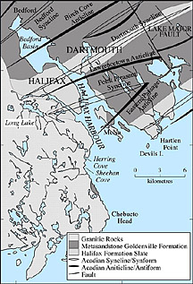
A detailed map of the bedrock geology of Halifax Harbour and surrounding areas. The slashes that cross the harbour represent folds (synclines and anticlines) in the bedrock. The harbour widens at the anticlines.
The location of these early rivers was thought to be controlled by faults (offsets, breaks) in the bedrock. These faults may have acted as zones of weakness for later river and glacial erosion. Based on the study of the bedrock in the harbour, there is little evidence for the presence of large faults. The major folded structures called "synclines" and "anticlines" (upward and downward folds) on either side of the harbour appear to line up without any offset from one side of the harbour to the other. Sidescan sonar and multibeam bathymetric images of bedrock show few faults or offsets within the areas of exposed bedrock on the seabed.
Bedrock
Halifax Harbour owes its origin not to the presence of faults in bedrock, but to the distribution of different rock types. There are three different bedrock types in the harbour and surrounding region. These are Halifax Formation slate, Goldenville Formation quartzite, and Devonian granite. The Goldenville Formation has thick beds with widely spaced rock ridges in contrast to thin bedding and closely spaced ridges of the Halifax Formation. The Devonian granite displays a massive uneven surface shape. The contact of the slate and quartzite with the granite coincides with the location of the ancient Sackville River. It is irregular and rough which suggests that the contact is not related to a fault. The large, erosion-resistant granitic body confined the location of the early river systems to the weaker rocks east of the granite, in the area where the present harbour occurs.

A photograph of Chebucto Head showing the steep and rugged granite cliffs that form the western shore of the outer Harbour.
The bedrock of the inner harbour is buried beneath thick sediments. However, it is exposed at the seabed in several areas. Four bedrock ridges occur near the Dartmouth shoreline, southeast of the Dartmouth footing of the Angus L. Macdonald Bridge. The bridge footing is located on the most northern of the exposed ridges. In contrast, in the outer harbour bedrock apears at the seabed surface in 50% of the area.
As glaciers moved through the harbour, differences in the bedrock type and structure controlled the amount of erosion as well as the width and shape of the present harbour. As the ice moved across the Halifax Formation slate it was not able to erode the material as readily as it could over the Goldenville Formation quartzite beneath the basin and in other areas of the harbour. The widely spaced fractures and thick beds allowed the Goldenville Formation to be more easily eroded, whereas the Halifax Formation with its thinner beds allowed only limited glacial removal and the generation of smaller fragments. Therefore, glaciers eroded much less over the Halifax Formation. This differential erosion resulted in the present topographic high of the peninsular part of Halifax and the narrow channel of The Narrows. The high, resistant granite cliffs remain along the western side of the harbour from Herring Cove to Chebucto Head.
Early river systems
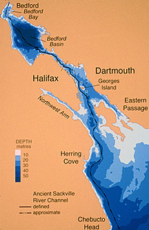
A map of water depths in Halifax Harbour with the location of a former river channel, the Ancient Sackville River that existed when sea level was lower.
The location of Halifax Harbour is controlled not by faults within the bedrock, but by the distribution of the hard granite to the west of the harbour. It confined the location of early river systems to weaker rocks in the east. A large channel to the east of the granite occurs beyond the mouth of Halifax Harbour that connects with the harbour. The name 'ancient Sackville River' has been given to this feature.
An ancient preglacial Sackville River likely flowed through the area of Bedford Basin, the harbour and continued across the inner Scotian Shelf. A deep inner harbour buried basin that trends toward Dartmouth Cove, suggests another drainage system may have joined the Sackville River in the inner harbour to the north of Georges Island. Such a system existed in the present location of a series of lakes in Dartmouth: Banook, Charles, and Micmac, that presently empty into Dartmouth Cove. This system also was a spillway for later glacial lakes in central Nova Scotia. It is likely that these two early drainage systems contributed to the formation of Halifax Harbour. The exact location of the preglacial drainage system is difficult to locate beneath the thick, gas-charged sediments of the inner harbour and in the over-deepened Bedford Basin, but it was clearly confined to the western part of the outer harbour. A curved section of the old Sackville River can be seen on the floor of the Narrows.
Glaciation, drumlins and moraines
Before Pleistocene glaciation, which began approximately two million years ago, Halifax Harbour existed only as a river system. Bedford Basin was not the isolated circular depression as it is today. The ancient Sackville River extended across the region through the present area of the basin, and out of the harbour along the outer western part. Glaciers eroded and over-deepened (dug deeper than the river channel) the area of Bedford Basin by more than 50 m largely following the course of the earlier river system. It is not known which of the many glaciations created the extensive erosion of the basin and perhaps all glaciations contributed to some degree. As a result of the glacers over-deepening the basin, a continuous river channel for the ancient Sackville River ceased to exist. From then on, when the glaciers were absent, Bedford Basin was a lake.
The last major period of glaciation (Wisconsinan) began at about 75 000 years ago and the ice sheet extended across the entire region to the edge of the Scotian Shelf over 100 km away. Ice retreated to the inner Scotian Shelf during the mid-Wisconsinan Phase, 40–22 thousand years ago. During this time the area of Halifax Harbour likely remained under ice cover. This was followed by the Escuminac phase of the Late Wisconsinan, 22–18 thousand years ago, with an advance of ice that was centred over the Gulf of St. Lawrence. This glacial ice transported and deposited large quantities of red till to the shelf edge. This till is termed the Lawrencetown Till and it contains more clay than the underlying Hartlen Till and is less compact. It was this ice that formed the drumlins of Halifax Harbour: Jonquière Bank, ‘Little Georges Bank’, and Georges Island, as well as the many drumlins of the surrounding land areas such as ‘Halifax Citadel National Historic site of Canada also called 'Citadel Hill', ‘Fort Needham Memorial Park’, and McNabs and Lawlor islands.
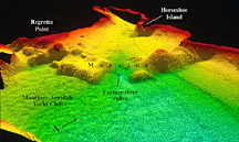
A 3 d multibeam bathymetric image looking north toward an end moraine (ridge of till) at the head of the Northwest Arm deposited by a glacier that terminated there.
By 18 000 years ago, Wisconsinan ice began to retreat and was followed by the Scotian Phase that resulted in a major change in ice-centre locations. The till deposited during this retreat phase is a stony, sandy till, derived from local bedrock sources with many angular boulders. It has been termed the "Beaver River Till" and was formed between 17 000–15 000 years ago. This till overlies both the Lawrencetown and Hartlen tills in drumlins and forms a bouldery till plain over most areas of the Atlantic coast including the area of Halifax Harbour.
By 13 000 years ago the ice margin was situated near the present-day Atlantic coast of Nova Scotia. As the glacial ice retreated up the Halifax Harbour, small linear moraines parallel to the front of the glacier, ice front, formed on Middle Ground, in the inner harbour northeast of Georges Island, and in the Bedford Bay. A prominent end moraine, ridge of rock and gravel left from the end of a glacier, was formed at the head of Northwest Arm during this time by a local readvancement of ice.
Between 11 000 and 10 000 years ago the climate of Nova Scotia cooled, which greatly affected the land and marine areas. Both lake and offshore sediment samples show a distinct coarsening, larger sized grains of sediment, that marks this event called the "Younger Dryas" period. Land-based glaciers were reactivated during this time and overrode pre-existing organic materials. On the inner shelf off Halifax, a distinctive, coarse sediment horizon and extensive local erosion of the sediments indicates increased storminess, sea ice, and possibly small icebergs.
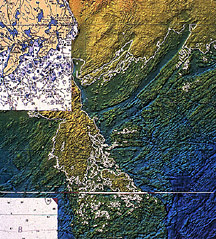
A multibeam bathymetric map off the entrance to Halifax Harbour. The white line is the location of the low sea level stand (beach) at approximately 12 000 years ago.
The sea-level history of Halifax Harbour is complex and controls not only the distribution of sediments on the seabed, but many of the other features as well. A low sea-level stand, the lowest average height of sea-level for a period of time, has been identified on the adjacent inner Scotian Shelf at a depth of between 65 m and 70 m that occurred at 11 600 years ago. This occurred at the end of the last glaciation. Since that lowering, areas above 65 m water depth have been transformed into a smooth surface of gravel, bedrock outcrop, and small areas of well sorted, coarse sand without silt and clay.
The early postglacial Halifax Harbour was confined to a narrow channel in the western part of the outer harbour. During this time the present major shoal areas in the east were land until approximately 7000 years ago. As sea level continued to rise, intense erosion occurred in the outer harbour. The present bedrock shoal areas east of the western deep channel had been covered with till and were subjected to large waves and strong currents at the shoreline. Most of the till was eroded, leaving only scattered boulders on bedrock. Similar processes are presently taking place today at the seaward, south side of McNabs Island, with erosion of the drumlins and exposure of the underlying bedrock. As the Sea moved into the outer harbour from sea-level rise, marine trangression, sand-sized material was transported and deposited in the deep channel of the western outer harbour where it remains today. Fine-grained mud was transported farther seaward on the inner continental shelf. The sea-level continued to migrate up the harbour which formated Sable Island Sand and Gravel.
In contrast to the erosion caused by the transgression in sea-level rise in the outer harbour, erosion was much less severe in the inner harbour because McNabs and Lawlor islands, sheltered the narrow entrance of the inner harbour, because the inner harbour was further from the open Atlantic Ocean. In many places tills were preserved and only their upper surfaces were modified. Fine-grained sediments were removed and larger angular broken rock remained.

A map showing the location of 10 lakes that existed in Halifax Harbour after the glaciers left and before the sea level returned and flooded the Harbour.
As a result of the glaciers over-deepening many areas of the harbour, the pre-existing river system (ancient Sackville River) was eroded, and many deep basins were created along its length. The Narrows still shows an exposed long, curve section of this river. Early postglacial lakes formed throughout the harbour in many of the over-deepened bedrock depressions and were connected by a river and stream system to the Atlantic Ocean. As many as ten lakes existed in the present area of the harbour.
The lakes were progressively flooded by the sea during the postglacial sea-level rise ("marine transgression") that began from the lowstand of -65 m off the mouth of the harbour. The transgression eroded and reworked the previously deposited glacial materials, forming well sorted sand and gravel deposits, areas of bedrock outcrop, and eroded drumlins at the seabed. By 5500 years ago, the ocean had progressed far enough up the harbour and was deep enough for mud (LaHave Clay) in the inner harbour. The sediment came from eroded glacial, lake, and estuarine materials. Bedford Basin, which was formerly a series of three lakes, was finally flooded by the rising sea at 5700 years ago when the shallow sill in The Narrows was breached by the rising waters. This changed the lake environment from freshwater to marine. This would have represented a major change to early peoples living in the area.
Lake Bedford, former islands, and old shorelines
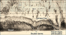
A sidescan sonar image of two boulder berms (ridges of boulders) in Bedford Basin that mark an old lake shore. They now lie in 23 m water depth and were formed approximately 6000 years ago.
People tend to think that the present shoreline is a permanent feature of the coast. This is not true as the ocean levels are constantly changing. In fact during glacial times, the ocean levels lowered as much as 120 m. Knowledge of sea-level history through mapping has provided new information on the location of former shorelines, islands, and lakes throughout the Halifax Harbour. Early peoples would have congregated and left artifacts at the shorelines and these areas are where marine archaeological studies are concentrated. The studies of former harbour shorelines have revealed much about the potential location of former habitation, migration, and activity sites.
When the last glaciers receded from the region the area of Bedford Basin contained at least three connected lakes: one in Bedford Bay, one in the main part of the basin, and another in southern Fairview Cove. The water level during this time is defined by former shorelines that occur at a present depth of 23 m. Two continuous berms (ridges) composed of boulders ring the basin at this depth. They were formed by winter freezing and ice expansion of the lake waters. Prior to 6000 years ago, Bedford Basin existed as a lake at a present depth of 23 m for a period of up to six thousand years during, which was when the boulder berms were formed. Similar ridges are common features today around the shores of many Nova Scotian lakes.

A multibeam bathymetric image of the northern part of Bedford Basin showing smooth seabed above the boulder berms at 23 m water depth, and rough seabed below.
The seabed is much different above and below the boulder berms (Figure 26). Below it is more rugged and is covered in mud. Above the berms, the seabed is flatter and smoother and is largely gravel covered with little mud. This is the result of a process called "marine transgression", whereby the seabed above the berms passed through the beach zone of the rising sea after the former lake (Lake Bedford) was converted to the ocean by the return of sea level from the glacial low stand. So prior to 6000 years ago, Bedford Basin existed as a lake at a present depth of 23 m for a period of up to 6 thousand years during which the boulder berms were formed.
The boulder berms also help identify the location of approximately ten ancient islands on the western side of Bedford Basin and a few small ones on the eastern side. In the area between Bedford Bay and Bedford Basin, there is a “sill” or shallow region that played an important role in the sea-level story. The seabed was exposed as a series of bedrock ridges during the same period of time when the islands in the basin existed. Part of an early Sackville River fell in a waterfall over these bedrock ridges connecting Bedford Bay to the basin. This area holds great potential for the discovery of archaeological artifacts. It is not difficult to imagine the landscape of the time as a highly favorable site for fishing, living, and an ancient short cut across the northern part of Bedford Basin.

